The Establishment of States:
Towards the conclusion of the Vedic period, the political structure of the Rig Vedic phase was replaced by that of territorial states, which marked the beginning of the end of the Vedic period.
The establishment of powerful states that used towns as their centres of government, however, began in the sixth century B.C. and progressively contributed to the consolidation of the territorial concept.

The establishment of a permanent settlement in a particular location provided a tribe or group of tribes with a geographical identity. Subsequently, this identity was given tangible shape in the control of the territory, which was typically called after the tribe. This possession requires some form of political organisation, such as a republic or a monarchy, in order to be maintained.
The extensive use of iron in eastern Uttar Pradesh and western Bihar, as demonstrated from excavations at Raj ghat and Chirand, led to the establishment of vast territorial entities that were better equipped militarily and in which the warrior class played the key role. This process began in the sixth century B.C. and continued forward.
The introduction of modern agricultural techniques and implements enabled peasants to increase their crop yields, resulting in a surplus that not only satisfied the requirements of the ruling class but also provided for the needs of a number of communities. The consolidation of commercial and industrial activities led to the development of towns. Some of these cities, like Shravasti, Champa, Rajagriha, Ayodhya, Kausambi, Kashi, and Pataliputra, played a significant role in the economics of the Ganges plains.
Others, like as Vaishali, Ujjain, and Taxila, in addition to the port of Bharukachchha (Broach), had a greater commercial reach. It is made abundantly apparent in a text from Panini that the people owed their allegiance not to the Jana or the clan to which they belonged but rather to the Janapada (territories) to which they belonged.
The Mahajanapadas, also known as the Republics and Monarchies:
During the post-Vedic period, the entire northern area, which is primarily located to the north of the Vindhyas and stretches from the North-West frontier to Bihar, was subdivided into sixteen states that were referred to as Sodasha Mahajanapadas. The character of these Mahajanapadas could be described as either monarchical or republican.
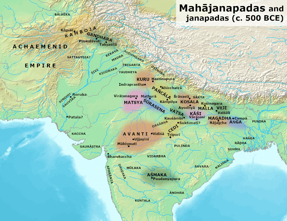
While the monarchy were centred in the Gangetic Plains, the republics were dispersed around the northern periphery of these kingdoms. These republics could be found in the foothills of the Himalayas and just south of these mountains, as well as in northwestern India in modern Punjab.
The Buddhist literature, particularly the Anguttara Nikaya includes the sixteen mahajanapadas listed as – Gandhara, Kamboja, Assaka, Vatsa, Avanti, Surasena, Chedi, Malla, Kuru, Panchala, Matsya, Vajji, Anga, Kosala and Magadha.
Monarchies:
- Kashi:
ADVERTISEMENTS:
Kashi, which had Banaras as its capital at the time, was initially the most powerful of the sixteen republics, and it is possible that it played a significant role in the overthrow of the Videhan dynasty. In the end, it was forced to bow down to the authority of Kosala, and Ajatasatru eventually incorporated it into Magadha.
- Kosala:
Its capital is located in Shravasti, which is equivalent to Sahet – Mahet and is located on the borders of the Gonda and Bahraich districts in the Indian state of Uttar Pradesh. This region encompassed the area that is now known as eastern Uttar Pradesh. Kosala was limited on the west by the river Gomati, on the south by the Sarpika or Syandika (Sai), on the east by the Sadanira (Gandak), which divided it from Videha, and on the north by the Nepal highlands. Kosala was also separated from Videha by the river Sadanira (Gandak).
Three of the most important cities in the Kosala region were Ayodhya, Saketa, and Shravasti. King Prasenjit of Kosala lived during the same time period as both King Bimbisara of Magadha and King Ajatasatru of Magadha. Kashi was given to Prasenjit’s sister as a dowry when she married King Bimbisara of Magadha, who was Prasenjit’s brother-in-law. But soon after that, conflict sprang out as a result of a dispute with Ajatasatru, who was Bimbisara’s son from another wife. Ajatasatru was the one who ended his father’s life, and his mother, who was Prasenjit’s sister, passed away as a result of her grief. As an act of retribution, Prasenjit took possession of Kasi.
A conflict broke out, the outcomes of which were unpredictable for both sides. In spite of this, peace was finally able to be restored after the fight. Kashi was given to Vajjira, daughter of Prasenjit, as part of the dowry she brought with her to her marriage to Ajatasatru. One of the statues in Bharhut illustrates the amicable relationship that existed between Prasenjit and Buddha, despite the fact that Prasenjit did not convert to Buddhism. After Prasenjit’s death, Magadha eventually took control of the territory and conquered it during Ajatasatru’s reign.
- Anga:
The current districts of Monghyr and Bagalpur are nearly equivalent to the ancient region of Anga, which is located in the east of Magadha. The city of Champa, which served as the nation’s capital and was located on the banks of the river of the same name, was renowned for its prosperity and commercial activity. During the reign of Bimbisara, it became a part of Magadha’s territory.
- Magadha:
The kingdom of Magadha, which corresponds to the present districts of Patna and Gaya, was located between Anga and Vatsa. It was surrounded on the north and west by the rivers Ganga and Son, on the south by the Vindhya Mountains, and on the east by the river Champa. The capital of Magadhan was known as Rajagriha or Girivraja, and it was protected by a boundary of five hills, making it impregnable. Brihadratha is credited with establishing the first dynasty in the Magadha region. Magadha, on the other hand, rose to prominence during the reigns of Bimbisasra and Ajatsatru.
- Vatsa:
The governance of the Vatsa nation was based on a monarchical system. Its capital was known as Kausambi, and it was located at what is now known as Kosam, which is around 61 kilometres from Allahabad. The most significant crossroads for trade and travel for people and products coming from the south and the west was the immensely prosperous city of Kausambi. This country’s monarch in the sixth century B.C., Udayana, had to fight against the king Ajatasatru of Magadha and the king Pradyota of Avanti in order to maintain his position.
Udayana formed a marriage connection with King Magadha by marrying one of his daughters. The ruler of Avanti attempted to conquer Kausambi by invading it, but he was ultimately unsuccessful and was forced to wed his daughter to Udayana. In the first, Udayana was against Ruddhism; however, as time went on, he converted to Buddhism and eventually proclaimed it the official religion of the empire. In later years, during the rule of Palaka, the kingdom of Avanti absorbed the territory of Vatsa.
- Avanti:
In general terms, the state of Avanti corresponded to what is now known as Malwa. The river Vetravati served as a divider between the northern and southern halves of Avanti. It was a large kingdom in terms of territory, and the city of Ujjayini, which is now known as modern Ujjain, served as the kingdom’s capital. Chanda Pradyota was Avanti’s king during Buddha’s lifetime. Avanti was ruled by Chanda Pradyota. He lived during the same time period as Udayana of Kausambi. Chanda was a nickname given to him because of his fierce nature; nevertheless, he later converted to Buddhism and gave up his moniker.
The Buddhist community that developed in Avanti grew to become very significant. Sishunaga was ultimately successful in annexing the kingdom of Avanti into the Magadhan Empire.
- Gandhara:
Gandhara was a state that roughly matched to the modern-day region of Kashmir and reached all the way up to the Kabul valley. Taxila, which served as the nation’s capital, was a renowned centre of education that attracted intellectuals from all over the world. In Buddhist tradition, it is said that King Pukkusati of Gandhara travelled to Magadha, exchanged presents with King Bimbisara of Magadha, and then made his way on foot to see the Buddha. According to Herodotus, a historian from Greece, it later became the twentieth province of the Achaemenid Empire, which was located in modern-day Iran.
- Kamboja:
Dwarka served as the nation’s capital and it was located adjacent to Gandhara in the far northwestern part of the continent. A little before 530 B.C., Cyrus, the Achaemenid monarch of Persia, crossed the Hindukush and took payments from the inhabitants of Kamboja, Gandhara, and the region around the trans-Indus region. During the time of Kautilya, Kamboja went through a transition from being a monarchy to a republic.
- Matsya:
The Matsyas might be found to the west of the Yamuna and to the south of the Kurus. The territory ruled by the Matsya people roughly corresponded to what is now the state of Rajasthan known as Jaipur.
- Kurus:
The area that closely matched to modern-day Delhi and the surrounding doab region was known as the Kuru country. During the later Vedic time, it was the most significant kingdom, but during the sixth century B.C., the Kurus did not occupy the same status. They chose the city of Hastinapur, which is located in the Merrut district, to serve as their capital.
- Panchala:
During the time of the Vedic civilization, the kingdom of Panchala, which included the modern districts of Bareilly, Badaun, and Farukhabad, fell from its significant position. Their capital was located in Kampilla, which may have been the contemporary city of Kampil in the region of Farrukhabad.
Surasena and Chedi, numbers 12 and 13, respectively:
Mathura served as the seat of government for the kingdom of Surasena, which was located south of the Matsyas. The Jatakas contain a list of the kings who ruled over the Chedis throughout their reign, which generally corresponded to the eastern regions of Bundelkhand and the areas that bordered it.
Republics:
- Vajjis:
The land of the Vajji people was located to the north of the Ganges and reached all the way to the hills of Nepal. Its western boundary was the river Sadanira (Gandak), which also served as a natural barrier between it and the cities of Malla and Kosalan. In the east, it reached as far as the forests that are located on the banks of the Koshi and the Mahananda rivers. According to legend, the Vajji state was actually a confederation of eight different clans known as atthakula. The Videhans, the Lichchhavis, the Jnatrikas, and the Vrijjis proper were the most influential of these clans.
It is most likely that the Vajji confederation was established following the deterioration and collapse of the Videhan monarchy. The Vajji confederation was a republic during the time of Mahavira and Gautama Buddha. The Lichchhavis were the most powerful of these people, and their capital was located in Vaishali, which is the same place as the village of Basarh located in the Vaishali area.
- Mallas:
The landmass of the Mallas, which was governed by a republic, was split in half, with each section receiving its own capital city. The two cities that held the title of capital were Kushinara, also known as Kasia in the Gorakhpur district, and Pava, which is now known as Padrauna. Pava, where the Buddha consumed his final meals and fell unwell, and Kusinara, where he passed away, hold a particularly significant place in the annals of Buddhist history due to the fact that the Buddha passed away in the latter city.
- Assaka:
As time went on, the region around the river Godavari in the south, where the kingdom of Assaka (Asmaka) was located, grew in importance as a financial and commercial centre. Patlia or Potna served as the city’s capital. In contemporary politics, not all of the 16 Mahajanapadas played the same role. Kashi, which had been the most significant of the 16 at one point, was eventually overtaken in importance by Kosla and Magadha. These two kingdoms competed with one another for control of the Ganga basin, which, because of the commercial traffic along the river, had distinct political and financial advantages. As a result, the Ganga basin became a point of contention between the two countries.
By the sixth century B.C., there were only four states that were still in existence: Vatsa, Avanti, Kosala, and Magadha. The political history of India can be summarised as a series of power battles between various states beginning in the sixth century B.C. and continuing until the present day. In the end, it was the kingdom of Magadha that rose to prominence as the most powerful and was successful in establishing an empire.